Understanding the Four Routes Is the First Step to a Successful Climb
Mt Fuji has four officially maintained climbing routes: the Yoshida Route on the Yamanashi (north) side, and the Subashiri, Gotemba, and Fujinomiya routes on the Shizuoka (south) side. Each route starts at a different elevation, covers a different total distance, presents a different gradient and terrain character, and has a different number of mountain huts available for rest or overnight stays.
Your choice of route directly affects your safety, your comfort, and the quality of your experience. This guide breaks down all four routes in detail so that climbers of every experience level — from complete first-timers to seasoned mountain walkers looking for a new challenge — can make a fully informed decision.
After climbing Mt Fuji eight times across multiple routes, my honest advice to first-timers is simple: take the Yoshida Route. No other route offers the same density of mountain huts, escape options if something goes wrong, or reassurance that help is nearby. Once you have that first ascent under your belt, the Subashiri, Fujinomiya, and Gotemba routes each offer something genuinely different and worth experiencing.
— Editorial team, experienced mountain guideFour-Route Comparison Table: At a Glance
| Feature | Yoshida | Subashiri | Gotemba | Fujinomiya |
|---|---|---|---|---|
| Prefecture | Yamanashi | Shizuoka | Shizuoka | Shizuoka |
| 5th Station Elevation | 2,305 m | 2,000 m | 1,450 m | 2,400 m |
| Ascent Time | approx. 5–7 hrs | approx. 5–8 hrs | approx. 8–10 hrs | approx. 4–6 hrs |
| Descent Time | approx. 3–4 hrs | approx. 3–4 hrs | approx. 4–5 hrs | approx. 2–3 hrs |
| One-Way Distance | approx. 7 km | approx. 8 km | approx. 11 km | approx. 5 km |
| Elevation Gain | approx. 1,471 m | approx. 1,776 m | approx. 2,326 m | approx. 1,376 m |
| Difficulty | ★ Beginner–Intermediate | Intermediate | Advanced | Intermediate–Advanced |
| Mountain Huts | approx. 40 (most) | approx. 10 | approx. 5 (fewest) | approx. 10 |
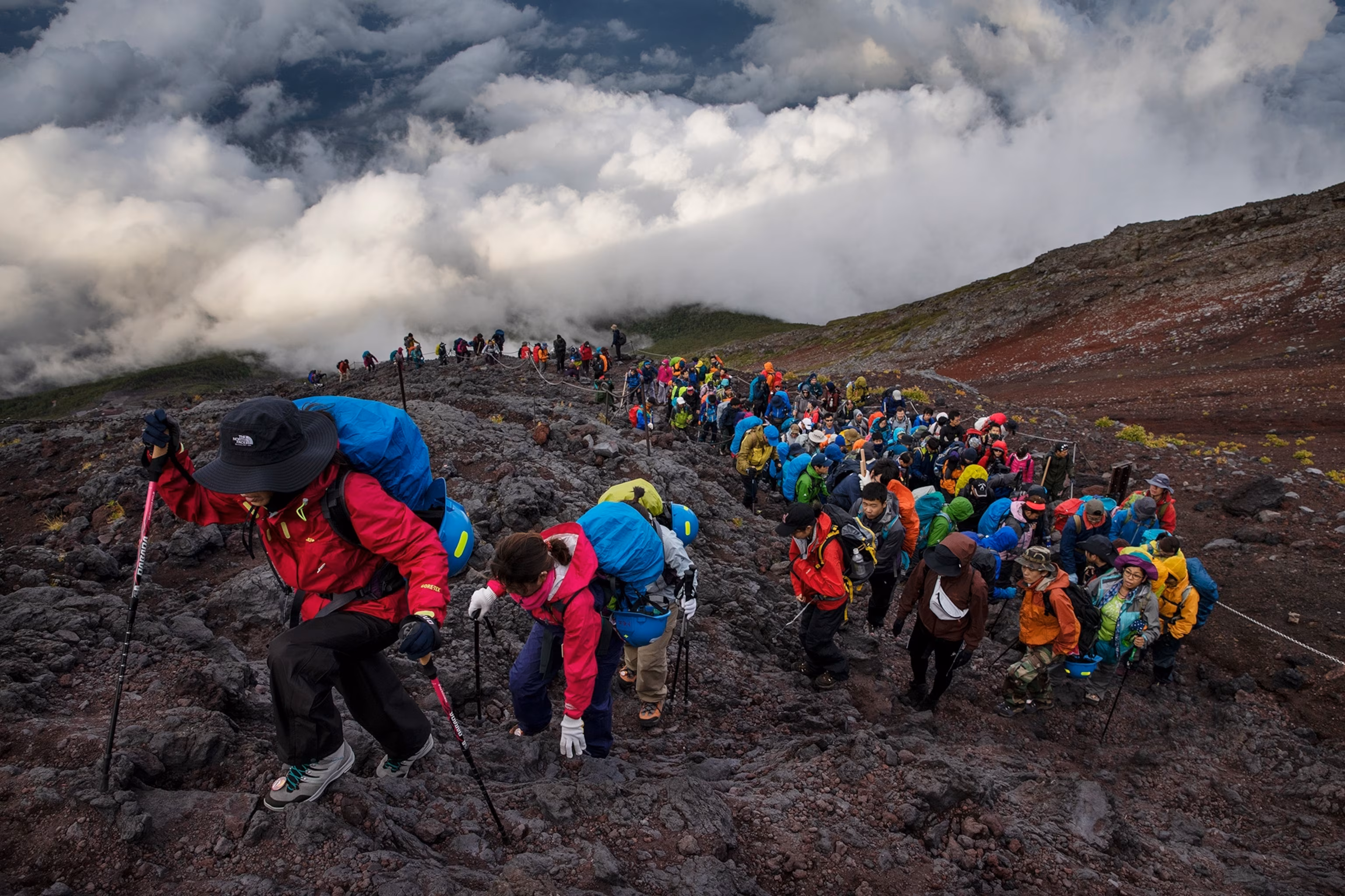
| Climber Traffic | Most (approx. 60% of all climbers) | Moderate | Least | High |
| Separate Descent Trail | Yes (Yoshida descent trail) | Sand Run descent | Great Sand Run descent | No (shared trail) |
| Access from Tokyo | ✓ Best (~2.5 hrs) | Good (~3 hrs) | Moderate (~3.5 hrs) | Good (~3 hrs) |
| Recommended for Beginners | ★★★★★ Top Recommendation | ★★★☆☆ | ★☆☆☆☆ | ★★☆☆☆ |
* All times and distances are approximate. Individual fitness, pace, and weather conditions can alter actual times significantly.
Yoshida Route: The Classic Choice for First-Time Climbers
Route Overview
The Yoshida Route carries approximately 60% of all Mt Fuji climbers each year and is by far the most popular trail on the mountain. It ascends from the Yamanashi side, with the 5th Station at 2,305 m and a direct bus connection from Shinjuku in about 2.5 hours — the fastest and easiest access from Tokyo of any route.
The route's defining advantage is the sheer number of mountain huts: roughly 40 facilities are distributed from the 5th Station to just below the summit. These huts provide shelter, food, emergency rest points, and overnight accommodation, dramatically reducing the consequences of unexpected bad weather or sudden illness. The trail also has completely separate ascending and descending paths, which reduces traffic congestion and helps maintain a consistent walking pace.
Why Beginners Should Choose the Yoshida Route
- Most mountain huts of any route (~40) — a safe haven is never far away
- Best-maintained trail on the mountain with abundant signage
- High climber density means you are rarely alone, reducing isolation risk
- The primary departure point for guided tours in English, Japanese, and Chinese
- Direct bus service from central Tokyo (Shinjuku) — simplest logistics
- Most comprehensive emergency rescue infrastructure on the mountain
🗺 Yoshida Route — Key Data
| 5th Station Elevation | 2,305 m |
| Distance to Summit | approx. 7 km (one way) |
| Elevation Gain | approx. 1,471 m |
| Ascent Time | 5–7 hours |
| Descent Time | 3–4 hours |
| Mountain Huts | approx. 40 |
| Difficulty | Beginner–Intermediate |
Key Mountain Huts on the Yoshida Route
| Name | Elevation | Station | Notes |
|---|---|---|---|
| Sato Goya | 2,230 m | Below 6th Station | Historic hut; approx. 30 min walk from the 5th Station |
| Hanagoya / Hinodemakan | 2,700 m | 6th–7th Station | Popular rest stop for climbers during the ascent |
| Kamaiwa-kan / Fujiiichi-kan | 3,010 m | 7th Station | Cluster of huts; overnight accommodation available |
| Taishikan / Ganso-muro | 3,100–3,400 m | 8th Station | The most popular overnight base for a Goraiko summit push |
| Fujisan Hotel / Choojo Fujikan | 3,720 m | 9th Station–Summit | Near the summit; food, supplies, and accommodation available |
If you are climbing the Yoshida Route, the 7th Station huts are actually the optimal overnight stop. Staying lower than the 7th Station risks not having enough time to reach the summit before sunrise. But staying higher than the 8th Station means the air is extremely thin, which makes sleep difficult and can worsen altitude sickness symptoms. The 7th Station cluster at 3,000–3,100 m hits the sweet spot between acclimatization and Goraiko logistics.
— Editorial team, experienced mountain guideSubashiri Route: Forests, Tranquillity, and the Legendary Sand Run
Route Overview
The Subashiri Route departs from Oyama-cho in Shizuoka Prefecture, with the 5th Station sitting at 2,000 m — 305 m lower than the Yoshida trailhead. This means a greater total elevation gain, but the lower starting point provides something no other route offers: a genuinely immersive forest section in the lower half of the trail. Walking through the sub-alpine forest with its towering fir trees and relative silence feels entirely different from the open volcanic scree that dominates the upper mountain.
The Subashiri's most celebrated feature is its Sunabashiri descent — a long sand-run trail from the 7th Station to the 5th Station along a slope of deep volcanic cinders. With the right technique (big, loping strides, leaning back slightly), you can cover the descent in a fraction of the normal time, with a sensation unlike anything else on the mountain.
The Subashiri trail merges with the Yoshida Route at the 8th Station, meaning the upper mountain section is shared. However, the lower section (5th to 7th Station) is noticeably quieter than the Yoshida trail.
Who the Subashiri Route Is Best For
- Climbers on their second or subsequent Mt Fuji ascent
- Those who want to experience sub-alpine forest walking
- Anyone eager to try the Sunabashiri sand run
- Climbers looking to avoid Yoshida's peak-season crowds on the lower trail
- Physically fit hikers comfortable with a higher elevation gain
🗺 Subashiri Route — Key Data
| 5th Station Elevation | 2,000 m |
| Distance to Summit | approx. 8 km (one way) |
| Elevation Gain | approx. 1,776 m |
| Ascent Time | 5–8 hours |
| Descent Time | 3–4 hours (using Sunabashiri) |
| Mountain Huts | approx. 10 |
| Difficulty | Intermediate |
Key Mountain Huts on the Subashiri Route
| Name | Elevation | Station | Notes |
|---|---|---|---|
| Sugawara Goya | 2,950 m | 7th Station | First major overnight hut on the route |
| Miharashi-kan | 3,000 m | New 7th Station | Gas stoves available; meals served |
| Edoya | 3,400 m | 8th Station | Overnight accommodation; used as a base for Goraiko summit pushes |
| (Merges with Yoshida Route) | 3,400 m+ | Above 8th Station | Above this point, trails and huts are shared with the Yoshida Route |
Gotemba Route: The Longest, Most Demanding, and Most Solitary
Route Overview
The Gotemba Route starts from Gotemba City in Shizuoka Prefecture, with the lowest 5th Station of any route at just 1,450 m. From this low starting point to the 3,776 m summit, the route climbs approximately 2,326 m over roughly 11 km — making it the longest, highest-gain, and most physically demanding of the four routes. Ascent times of 8–10 hours are standard, and the route is unambiguously reserved for experienced mountain hikers.
What the Gotemba Route lacks in convenience, it more than compensates for in atmosphere. Climber numbers are the lowest by a significant margin, and on weekday mornings below the 6th Station you may encounter almost no one. The open volcanic landscape — unbroken scree and sky — creates a starkly beautiful, meditative hiking experience that the busier routes cannot replicate.
The descent route features the Great Sand Run (Osunabashiri), approximately 6 km of loose volcanic cinders running from the 7th Station to the 5th Station. It is the longest and most dramatic sand descent on the mountain.
Who the Gotemba Route Is Best For
- Climbers with 2–3 or more previous Mt Fuji ascents
- Those who prioritise solitude and quiet above all else
- Hikers who want to experience the Great Sand Run
- Those planning a relaxed 1.5- or 2-night itinerary
- Highly fit, experienced mountaineers seeking the full physical challenge
🗺 Gotemba Route — Key Data
| 5th Station Elevation | 1,450 m |
| Distance to Summit | approx. 11 km (one way) |
| Elevation Gain | approx. 2,326 m |
| Ascent Time | 8–10 hours |
| Descent Time | 4–5 hours (using Great Sand Run) |
| Mountain Huts | approx. 5 (fewest) |
| Difficulty | Advanced |
Key Mountain Huts on the Gotemba Route
| Name | Elevation | Station | Notes |
|---|---|---|---|
| Waraji-kan | 2,590 m | 6th Station | First overnight point on the long ascent |
| Sunabashiri-kan | 3,090 m | 7.5th Station | The main hut on the route; meals and overnight accommodation |
| Akaiwa Hachigo-kan | 3,300 m | 8th Station | Final overnight option before the summit; used for Goraiko departures |
| Gotemba-guchi Summit (Fujikan) | 3,710 m | Near Summit | Summit-area facility on the Gotemba approach side |
Fujinomiya Route: Shortest Distance, Steepest Climbing
Route Overview
The Fujinomiya Route ascends from Fujinomiya City in Shizuoka Prefecture and begins from the highest 5th Station of any route at 2,400 m. This head-start means the total distance and elevation gain to the summit are the smallest of the four routes. However, "short" emphatically does not mean "easy." The Fujinomiya trail is consistently steep, with rocky scrambling sections — particularly above the 9th Station — that require considerable physical effort and some use of hands on the rock. The route is better suited to experienced hikers than first-timers.
The Fujinomiya Route uses the same path for both ascent and descent, which can cause bottlenecks during peak-season weekends as uphill and downhill traffic must share the trail. Timing your descent for off-peak hours helps, but queueing is sometimes unavoidable. On the positive side, the route reaches the crater closest to the Hongu Sengen Shrine at the summit, making it a natural starting point for the Ohachimeguri crater rim walk.
Who the Fujinomiya Route Is Best For
- Experienced climbers on their second or subsequent Fuji ascent
- Those approaching from the Nagoya, Osaka, or Shizuoka direction
- Climbers who plan to do the full Ohachimeguri crater rim circuit
- Fit hikers who want the shortest route to the summit
- Those who enjoy technical rocky terrain
🗺 Fujinomiya Route — Key Data
| 5th Station Elevation | 2,400 m |
| Distance to Summit | approx. 5 km (one way) |
| Elevation Gain | approx. 1,376 m |
| Ascent Time | 4–6 hours |
| Descent Time | 2–3 hours |
| Mountain Huts | approx. 10 |
| Difficulty | Intermediate–Advanced |
Key Mountain Huts on the Fujinomiya Route
| Name | Elevation | Station | Notes |
|---|---|---|---|
| 6th Station Safety Guidance Centre | 2,490 m | 6th Station | Staffed checkpoint; first aid support available |
| Hoeizan-so | 2,590 m | New 7th Station | First proper overnight hut on the route |
| Yamaguchi Sanso (Motogomeyth Stn) | 3,010 m | 7th Station | Overnight accommodation; popular Goraiko base |
| Mannen Yuki Sanso | 3,460 m | 9th Station | One of the highest huts on the entire mountain |
| Fujinomiya Summit (Sengen Shrine) | 3,720 m | Summit | Hongu Sengen Grand Shrine at the summit; starting point for Ohachimeguri |
Which Route Should Beginners Choose?
The answer is unambiguous: first-time climbers should take the Yoshida Route. Here is the detailed reasoning.
✅ Why the Yoshida Route Is the Safest Choice for Beginners
- Most mountain huts (~40): A rest or emergency shelter is always within a reasonable distance
- Separate ascending and descending trails: No trail-sharing bottlenecks; you maintain your own pace
- Best trail maintenance: Signage is extensive and the path is clearly marked throughout
- Primary guided-tour hub: More English-, Japanese-, and Chinese-language guided tours depart from the Yoshida 5th Station than any other
- Best access from Tokyo: A direct bus from Shinjuku reaches the 5th Station in about 2.5 hours
- Strongest emergency response infrastructure: The highest volume of climbers means the quickest access to mountain rescue services
❌ Why Other Routes Are Not Recommended for Beginners
- Subashiri: Lower 5th Station elevation (2,000 m) means more total climbing; fewer huts; longer distance
- Gotemba: Japan's longest mountain trail; fewest huts; sections between water/shelter can be very long; expert-only
- Fujinomiya: Consistent steep gradient; rocky scrambling sections; shared ascending/descending trail creates congestion; limited escape options
Attempting the Subashiri, Fujinomiya, or Gotemba routes on your second or third climb is excellent and warmly encouraged.
Choosing a Route as an Experienced Climber
If you have already climbed Mt Fuji at least once, or have significant experience on other mountain trails, the following table will help you pick the route that best matches what you are looking for on your next ascent.
| Your Goal | Recommended Route | Reason |
|---|---|---|
| Maximum solitude and quiet | Gotemba Route | Fewest climbers by far; near-empty below the 6th Station on weekday mornings |
| Experience the sand run descent | Subashiri or Gotemba | Both offer unique volcanic cinder descents that are unique to Mt Fuji |
| Fastest summit time | Fujinomiya Route | Highest starting elevation and shortest total distance means the quickest ascent |
| Forest hiking and natural scenery | Subashiri Route | Lower section has a beautiful, quiet sub-alpine forest not found on other routes |
| Complete all four routes | Gotemba Route (save for last) | Traditionally considered the hardest and most rewarding way to complete the four-route challenge |
Descent Routes and the "Traverse" Option
It is possible to descend by a different route than the one used for the ascent. The most popular traverse combination is ascending via the Yoshida Route and descending via the Subashiri sand run, switching trails at the 8th Station where the two routes merge.
Yoshida Route Descent Trail
- Entirely separate from the ascending trail
- Well-maintained, clearly signposted sandy path
- Returns directly to the Yoshida 5th Station facilities
- Highest climber traffic; very low risk of getting lost
The safest and most recommended descent for first-time climbers.
Subashiri Sand Run Descent
- Volcanic cinder slope from the 7th Station to the 5th Station
- Large, loping strides allow rapid descent with good momentum
- Gaiters (leg covers) are essential to keep sand out of shoes
- Protect camera and phone from fine cinder dust
The popular traverse: ascend Yoshida, descend Subashiri, switching at the 8th Station.
Gotemba Great Sand Run Descent
- ~6 km of volcanic scree from the 7th Station to the 5th Station
- Open, panoramic views throughout the descent
- High pace can stress knees and thighs; use trekking poles
- Deeper sand sections require more energy than the Subashiri
The most dramatic scale of any descent trail — quintessentially Mt Fuji.
Fujinomiya Route Descent
- Uses the same trail as the ascent (no separate descent path)
- Shared trail creates congestion during peak season
- Steep rocky sections require extra care when descending
- No alternate descent options; build in extra time during busy periods
During peak season, start your descent early in the morning to avoid the worst queues.
Trail Conditions: Terrain, Gradient, and Hazard Zones
All Mt Fuji routes share a fundamental character: below the treeline (approximately 2,400 m), the trail passes through sub-alpine vegetation; above it, the mountain is bare volcanic rock and scoria (rough, porous lava). Understanding the specific terrain features of each section helps you choose the right footwear, trekking poles, and safety equipment.
The Fujinomiya and Gotemba routes have sections above the 8th Station requiring hand-on-rock scrambling. The Fujinomiya Route above the 9th Station is particularly steep and technical. In rain, these rock surfaces become very slippery. High-grip hiking boots with stiff soles are essential on both routes.
All four routes, particularly above the 7th Station, involve deep volcanic scoria — a reddish-black, rough-textured rock that is loose underfoot. The classic "two steps forward, one step back" sensation occurs when walking uphill through loose scoria. Zig-zagging the gradient and keeping a measured pace conserves energy effectively.
Wind speeds near the summit regularly exceed 15 m/s (54 km/h), and gusts above 30 m/s (108 km/h) are recorded each season. At 15 m/s, an umbrella is useless; at 20 m/s, standing upright becomes genuinely difficult. If strong-wind forecasts are posted for your planned summit day, seriously consider turning back at the 8th Station rather than pushing on.
Rockfall is a genuine hazard on all routes, particularly on the Yoshida Route between the 7th and 8th Stations where the trail ascends below steep rock faces. An increasing number of guided tours now require or recommend wearing a climbing helmet above the 7th Station. This is not excessive caution — lightweight trail helmets are available to rent at the 5th Station.
Seven Expert Tips for Choosing and Completing Your Route
The combination of mountain hut density, trail quality, access ease, and rescue infrastructure makes the Yoshida Route categorically safer for first-time climbers. Try other routes on subsequent visits.
A professional guide manages route selection, pacing, weather assessment, and emergency decisions. For first-time climbers, a guided package that includes equipment rental is the most reliable way to have a safe and enjoyable experience.
An overnight stay at a mountain hut allows your body to acclimatize properly, dramatically reduces altitude sickness risk, and lets you target the summit for the Goraiko sunrise — one of the most memorable experiences on the mountain.
All four routes are officially open only from early July to early September. Outside this window, mountain huts are closed, trail maintenance is suspended, and weather conditions can be dangerous or lethal. Do not attempt a non-season ascent without specialist winter mountaineering skills and equipment.
More than 70% of Mt Fuji accidents happen on the descent, when tired legs and overconfidence combine on steep, loose terrain. Know exactly which descent trail you are taking before you step off the summit, and don't change plans without a clear landmark to reference.
All four routes recommend filing a climbing registration form (Tozan届, Tozandoke). For the Yoshida Route it is effectively mandatory. The free "Compass" app makes electronic filing simple from your phone. The form gives rescue teams vital information about your planned route and schedule if you don't return.
Arriving overnight from Tokyo by bus and pushing straight to the summit with no acclimatization or rest is one of the most dangerous things you can do on Mt Fuji. Both Yamanashi and Shizuoka prefectures officially discourage it. The Yoshida Route now operates a nighttime gate closure to deter the practice. Always plan at least one hut overnight.
Frequently Asked Questions: Mt Fuji Climbing Routes
Mt Fuji has four official routes: the Yoshida Route on the Yamanashi (north) side, and the Subashiri, Gotemba, and Fujinomiya routes on the Shizuoka (south) side. Each has a different starting elevation, total distance, elevation gain, difficulty level, number of mountain huts, and terrain character.
The Yoshida Route is the overwhelming recommendation for first-time climbers. It has the most mountain huts of any route (approximately 40), the best-maintained trail, separate ascending and descending paths, the easiest access from Tokyo, and the most guided tour options in multiple languages. Save the other routes for your second or third climb.
Times vary by route and individual fitness. The Yoshida Route takes approximately 5–7 hours to ascend and 3–4 hours to descend. The Fujinomiya Route is shorter at 4–6 hours up and 2–3 hours down. The Gotemba Route is the longest at 8–10 hours up and 4–5 hours down. For an overnight Goraiko plan, total active time across two days is roughly 10–14 hours.
The Sunabashiri is most associated with the Subashiri Route's descent trail, running from the 7th Station to the 5th Station. The Gotemba Route also features the "Great Sand Run" (Osunabashiri), approximately 6 km of volcanic scree — the longest sand descent on the mountain. Gaiters (leg covers over shoes) are essential on both.
The Yoshida Route (Yamanashi side) is longer, has a gentler gradient, and has approximately 40 mountain huts — making it the ideal beginner route. The Fujinomiya Route (Shizuoka side) starts from the highest 5th Station (2,400 m), is the shortest in distance, but is consistently steep and rocky throughout and is best suited to experienced hikers. As of 2024, only the Yoshida Route has a mandatory access fee (¥2,000) and a daily entry cap.
The Gotemba Route has the greatest elevation gain of any route (approximately 2,326 m) and the longest one-way distance (approximately 11 km). It also has the fewest mountain huts (approximately 5), meaning significantly greater distances between shelter and water points. The monotonous volcanic scree of the long middle section tests endurance as much as fitness. However, for experienced climbers, the solitude, scale, and Great Sand Run descent make it uniquely rewarding.
From the 2024 climbing season, the Yoshida Route imposes a mandatory trail access fee of ¥2,000 per person with a daily cap of 4,000 climbers and advance reservation required. The other three routes (Subashiri, Gotemba, Fujinomiya) did not have a mandatory fee as of 2024, though a voluntary conservation donation of ¥1,000 is requested. Regulations can change each season — always check the latest policy on the official Mt Fuji climbing portal before you travel.
Find the Right Route and Conquer Mt Fuji
From beginner-friendly guided Yoshida Route tours to specialist itineraries on the Gotemba and Subashiri routes, there is a Mt Fuji climbing experience for every level. If you are unsure which route to choose, a guided tour operator can help you decide based on your fitness and goals.
Book a Mt Fuji Climbing Tour ➔